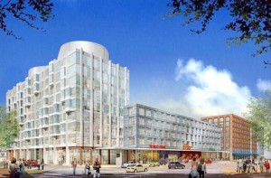
The Harrison Albany Corridor Strategic Plan represents a development guide for the future of the strip of land sandwiched between I-90 and the more residential portion of the South End. Mayor Thomas M. Menino recognized the area’s potential for redevelopment and appointed a 30 member Impact Advisory Group to design a master plan for the area, which was predominantly a light industrial zone. The Advisory Group broke the area into four sub-areas, each with its own unique neighborhood traits that should be preserved while paving the way for future development.
The New York Streets sub-area connects the South End to Chinatown and downtown, while the SOWA area represents a mixed-use arts and residential area. Beyond that, the Back Streets sub-area houses several light industrial sites, and connects the Boston University Medical Area and associated campuses to the rest of the South End. The BRA and the Advisory Group took these requirements into consideration to design a planning document that would modify portions of the South End Neighborhood District zoning code to make the area more attractive to new, mixed-use developments.
After the Advisory Group published its strategic plan, the BRA Board of Directors approved it and the recommended zoning changes were adopted by the Boston Zoning Commission.
The flagship project for area is National Development’s “Ink Block”. The former home of the Boston Herald, a six acre city block, will become four new buildings with 475 apartments, a Whole Foods grocery store, and street level retail. The 550,000 square foot development is scheduled to begin construction in March 2013. A new ad campaign encourages people to “Think Ink.”
See the planning documents here.
